
Restrictions come into effect as of noon, July 14th, 2021
Please sign up for RDCK emergency alerts to be notified in case of evacuation notice or order or any other significant emergency events: https://www.rdck.ca/EN/main/services/emergency-management/emergency-alerts.html?fbclid=IwAR0Mty3CNH4s7lAhA82COZFCuwBDKkTv66Yx5F5xAxuabcy35zBFDHzhxvI
| 7/13/2021 4:35 PM |
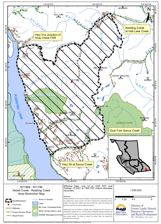
| CASTLEGAR — The BC Wildfire Service continues to monitor the Akokli Creek (N71876) and Redding Creek (N11795) wildfires located in the Kootenay Lake and Cranbrook zones. The Akokli Creek fire is about 7.5 kilometres northeast of Boswell while the Redding Creek fire is about 14 kilometres northeast of the community of Boswell.CASTLEGAR — The BC Wildfire Service continues to monitor the Akokli Creek (N71876) and Redding Creek (N11795) wildfires located in the Kootenay Lake and Cranbrook zones. The Akokli Creek fire is about 7.5 kilometres northeast of Boswell while the Redding Creek fire is about 14 kilometres northeast of the community of Boswell. In the interest of public and responder safety, an area restriction will be going into effect at 12:00pm (noon) on Wednesday, July 14, 2021 within the Akokli Creek and Redding Creek areas: • Commencing at highway 3a Junction of Gray Creek Pass Forest Service Road (FSR), south to the junction of Sanca Creek and highway 3a , east following Sanca Creek to the height of land east of Jackson Peak, then north following the height of land to Redding Creek FSR. • West on the Redding Creek FSR to the Gray Creek Pass FSR, continuing to the commencement point at highway 3a. • Lockhart Beach Provincial Park and campgrounds adjacent to highway 3a are not included in the area restriction. • Note: Access along the Gray Creek Pass FSR and Redding Creek FSR is permitted but entrance into the restricted area from those FSR’s is prohibited. Under this Order and section 11(2) of the Wildfire Act, a person must not remain in or enter the restricted area, unless the person: 1.) first receives written authorization of an official designated for the purposes of the Wildfire Act, or 2.) enters the area only in the course of: (a) travelling to or from his or her residence, that is not under an evacuation order; (b) using a highway as defined in the Transportation Act; (c) travelling as a person acting in an official capacity as defined in s.56 of the Wildfire Act; or (d) travelling for the purpose of supporting wildfire suppression or enforcement patrol activities. AMENDMENT: Lockhart Beach Provincial Park and campgrounds adjacent to highway 3a are not included in the area restriction. A detailed map of the affected area is available: http://ow.ly/VDmN50Fvlhw Failure to comply with Section 11 restricted area requirements may result in a violation ticket of $1,150. Road closures and area restrictions are subject to change depending on fire activity. For the most current information please visit the bans and restrictions section of the BC Wildfire website for the Southeast Fire Centre, or visit: http://www.ow.ly/k5jT50Fvlk3 The Southeast Fire Centre extends from the U.S. border in the south to Mica Dam in the north, and from the Okanagan Highlands and Monashee Mountains in the west, to the B.C.-Alberta border in the east. To report a wildfire call 1 800 663-5555 toll-free or *5555 on a cellphone. For the latest information on current wildfire activity and burning restrictions visit: http://www.bcwildfire.ca or download the BC Wildfire App free for Apple and Android devices. Follow the latest wildfire news: • Twitter at: http://twitter.com/BCGovFireInf • Facebook at: http://facebook.com/BCForestFireInfo Contact: Fire Information Officer BC Wildfire Service Southeast Fire Centre 250 318-7715 Connect with the Province of B.C. at www.gov.bc.ca/connect |
| Fire Centre Bulletin 3369 |